Aerial Photos & GPS Mapping: Seeing Your Property Like Never Before
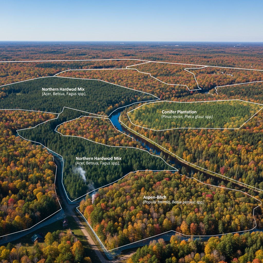
Most landowners see their property from ground level: walking trails, standing at property lines, viewing from their house. That perspective is valuable, but it's incomplete. From above, at a distance, your forest reveals itself differently. You see the full mosaic of tree heights and types. You understand the scale of your property in relation to neighbors. You visualize harvest zones, access routes, and management opportunities that aren't visible from the ground. Aerial photography and GPS mapping fundamentally change how you understand your property and how you manage it.
The Power of Aerial Perspective
Modern drone technology has revolutionized forestry. High-quality aerial photographs provide clarity that was impossible just a decade ago. We can see tree canopy colors and textures that indicate species composition. We can identify understory vegetation and gaps. We can spot wetlands, rock outcroppings, and other features that influence management. We can show your property boundaries clearly in relation to neighbors' properties. And we can do all this while respecting your privacy and safety—drones don't require ground access to every part of your property.
Beyond simply seeing your property, aerial photography creates a permanent record. You can track changes over time by comparing photos taken years apart. You can document conditions before and after management activities, creating proof of work completed and forest improvements. You can share photos with family, neighbors, or buyers to communicate your property's size, beauty, and value. Many landowners find that seeing their property from the air shifts how they think about it—suddenly, you see the scale of your stewardship and understand why professional management matters.
GPS Mapping: Precision and Documentation
Aerial photos are beautiful, but they need precision to be useful for management. That's where GPS mapping comes in. We use precision GPS to verify your property boundaries, map property lines in relation to neighbors, and identify boundary corners. Boundary verification alone is worth the investment—disputes over property lines can be expensive and contentious. Knowing exactly where your property begins and ends prevents misunderstandings with neighbors and ensures harvests, plantings, or other activities respect boundary lines.
Beyond boundaries, we use GPS to map forest stands—distinct areas of forest with different characteristics. Stand mapping shows exactly where different tree types, ages, and conditions exist. We map existing features: trails, roads, water bodies, rock outcroppings, wildlife food sources, and recreation areas. We create layers showing optimal harvest zones, forest health improvement areas, and wildlife enhancement zones. All this information is overlaid on your aerial photos and organized into maps that guide management decisions.
Integration with Management Planning
The real power of aerial photos and GPS mapping emerges when they're integrated with forest stewardship planning. Instead of having a verbal or vague idea of where to harvest or enhance habitat, you have precise, mapped recommendations. Contractors know exactly where to work and where to avoid. You can see on a map exactly which stands will be harvested in which year of your 10-year plan. You can visualize how food plots will be positioned relative to trails and viewing areas. You can understand access routes and infrastructure needs.
This integration also supports better decision-making. Instead of deciding in the abstract where to do work, you're looking at a precise map of conditions. You understand hydrology, adjacencies, and logistical factors that influence management. You can see how management in one area affects opportunities in adjacent areas. The result is better-informed, more strategic decisions that achieve your goals more effectively.
Marketing and Communication Value
Beyond management, aerial photos are powerful communication tools. If you ever sell timber, you can show contractors exactly what you're selling and where it's located. If you apply for grants or tax programs, aerial documentation strengthens your application. If you want to bring family members or potential buyers to your property, showing them aerial photos first—highlighting key features and explaining your management—helps them understand what they're about to see on the ground.
Many landowners display aerial photos of their property—they're genuinely beautiful, offering a perspective most people never see. They create a sense of pride in stewardship and help communicate to others why professional forest management matters. They tell the story of your land in a way that ground-level viewing simply can't.
Planting and Regeneration Documentation
If your management plan includes planting or natural regeneration, aerial photography provides invaluable documentation. You can map exactly where planting occurred, what species were planted, and how they're thriving several years later. You can track regeneration success visually. You can identify areas where additional planting or management might be needed. This documentation supports grant applications and tax program participation—administrators want to see proof that management activities actually occurred and achieved their intended results.
For regenerating stands, year-to-year aerial photos show dramatically how young growth establishes itself. The visual difference between year one (bare ground) and year five (young dense forest) is remarkable and satisfying. These photos become part of your property's management record, demonstrating responsible stewardship over the long term.
Getting Your Property Mapped and Documented
Whether you're just getting started with forest management or already deep into a stewardship plan, aerial photos and GPS mapping add tremendous value. We can provide high-quality aerial photography, boundary verification, stand mapping, and maps showing management recommendations and opportunities. The result is a clear, visual picture of your property that informs better decision-making, supports planning and communication, and becomes part of your permanent property documentation.
If you haven't seen your property from the air, or if you'd like more detailed mapping to support your forest management, we'd love to help. Professional aerial documentation is more affordable than many people realize, and the value—in terms of better planning, clearer communication, and beautiful documentation of your land—is substantial.
Ready to See Your Property from Above?
Let's provide aerial photos and GPS mapping to clarify your property and guide management decisions.
Schedule Your Free Consultation